
The Hammer Ergatta
- Feb 13, 2011
- indoor
- Tony DeCarlo Varsity Center
- University Heights, OH (USA)
- Hosted By: John Carroll University Rowing
- 2016 Registered Regatta
Address:
John Carroll University
20700 N Park Blvd
University Heights, Ohio 44118
Maps:

Driving Directions:
From the Greater Cleveland Area:
The JCU Campus is located in suburban University Heights near the intersection of Fairmount Boulevard and Warrensville Center Road. It is approximately 12 miles east of Public Square and four miles east of University Circle.
The following are suggested routes to the campus from various points in Greater Cleveland and environs:
From 1-271
Take 1-271 (Local not to Exit 32
(Cedar/Brainard Roads exit). Follow Cedar Road west for 2.5
miles to South Belvoir Blvd. Turn left onto South Belvoir and
travel south 0.7 miles. The entrance to campus will be on your
right after crossing Washington Blvd.
From Downtown Cleveland
Take Carnegie Avenue east to its end at University Circle and follow traffic ynder the bridge and up Cedar Hill, Stay in the right-hand lane and, at the top of Cedar Hill, bear right onto Cedar Road and move into the middle lane. Follow Cedar Road east to South Belvoir Blvd. (about 4 miles from the top of Cedar Hill). Turn right onto South Belvoir and travel south 0.7 miles. The entrance to campus will he on your right after crossing Washington Blvd.
From West Side Areas Convenient to Memorial Shoreway: Follow the Shoreway east to the Martin Luther King Drive exit. Follow MLK to University Circle, then Cedar Road to Fairmount Blvd., as described above.
From I-77 or I-71 Close to Downtown:
Exit at East 22nd Street and Carnegie Avenue, and then follow the directions from downtown, as above.
From Southern Suburbs via I-271:
Take I-271 north to the Cedar Rd. exit (Exit #32). Go right (west) on Cedar Rd. to South Belvoir Blvd. Turn left (south) on South Belvoir. The campus is approximately 3/4 mile.
From Lake County via I-90:
Take I-90 to I-271, and follow I-271 south to the Cedar Rd./Brainard Rd. exit. Turn left (south) at the end of the exit ramp, onto Brainard Rd. Then go right (west) onto Cedar Rd. to South Belvoir Blvd. Turn left (south) on South Belvoir. The campus is approximately 3/4 mile.
The campus is also served by RTA bus routes along Warrensville Center Rd. (41). The RTA Shaker Rapid (Green Line) stop at Warrensville Center Rd. is approximately 3/4 mile south of campus. For more information on schedules and routes, call the RTA Main Office at 216-566-5100 or visit their website at: http://www.gcrta.org/
From Outside Greater Cleveland Area:
From the East:
Via the Ohio Turnpike (Pittsburgh, Philadelphia, Washington, D.C.), exit the Ohio Turnpike at Gate 187; follow I-480 West to I-271 North. Continue with directions from I-271.
Via I-90 (Buffalo, Rochester, Syracuse, New York City, and New England), take I-90 West to I-271 South (Local Lanes, not Express). Continue with directions from I-271.
Via I-480 (Youngstown), take I-480 West to I-271 North. Continue with directions from I-271.
From the Local East Side Suburbs, take I-271. Continue with directions from I-271.
From the West:
Via the Ohio Turnpike (Toledo, Detroit, Chicago), exit the Ohio Turnpike at Gate 151; follow I-480 East to I-271 North. Continue with directions from I-271.
From the Local West Side Suburbs , take I-71 North to I-480 East; follow I-480 East to I-271 North, or take I-90 East to I-271 South (Local Lanes, not Express). Continue with directions from I-271.
From the South: (via I-77 or I-71):
Via I-71 (Akron, Columbus, Cincinnati), take I-71 North to I-271 North. Continue with directions from I-271.
Via I-77 (Akron, Canton, Marietta), take I-77 North to I-271 North. Continue with directions from I-271.
From Cleveland Hopkins International Airport:
Take I-480 East to I-271 North. Continue with directions from I-271.
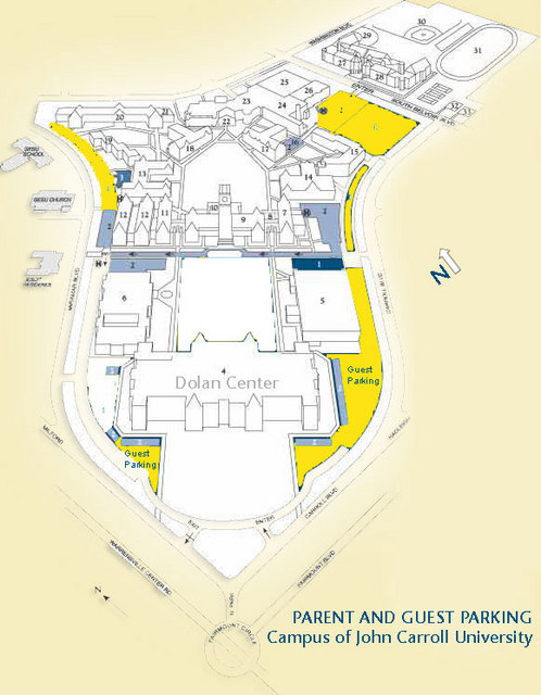
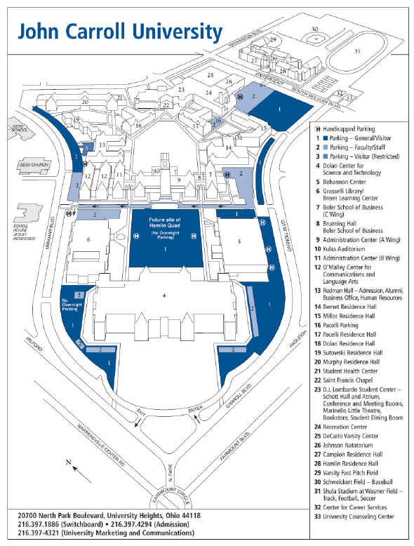
Links for Campus Parking Maps:
John Carroll University Campus Map
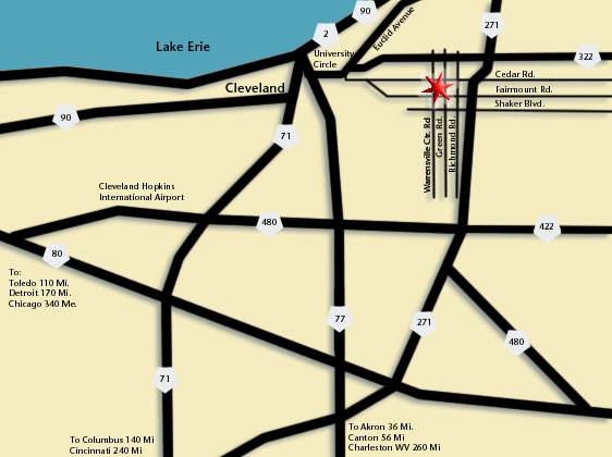
John Carroll Location In Ohio