
Open Ocean Regatta
- May 1, 2022
- open water
- 2 Courses on San Francisco Bay
- Sausalito, CA (USA)
- Hosted By: Open Water Rowing Center
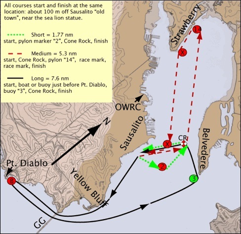
THE COURSES: The Open Ocean Regatta features two courses of varying length and water conditions for open water scullers in shells and traditional boats. All courses start and finish at the same location, about 100 meters off of Sausalito ‘old town’ near the sea lion statue. All turns are accurate, but the path of travel is an approximation—part of the race is navigation and understanding the conditions!
Strawberry Course (5.3nm): Named for the Strawberry Peninsula, the Strawberry Course is 5.3 nm (10.4 km) in more protected water. The course starts from and returns to downtown Sausalito, navigating three buoyed turns to Strawberry Peninsula and back. This course can be completed in flat-water boats with favorable weather.
-
Start Line
-
Cone Rock (on port)
-
Pylon ‘14’ (on port)
-
Down Strawberry channel and around 5/6 channel markers
-
Race Mark / Orange Buoy (on starboard)
-
Finish Line
DISTANCES:
- From start, 0.85 nm. (recip. 192) to Cone Rock
- From Cone Rock, 1.91 nm. (recip. 119) to second turn (piling #14 )
- From second turn, 0.52 nm. (recip. 328) to Strawberry Point
- From Strawberry Point, 1.43 nm. (recip. 300) to final turn (orange buoy )
- From final turn, 0.59 nm. (recip. 2) to finish
COORDINATES:
- Cone Rock: 37 deg. 51.840’ N & 122 deg. 28.157’ W
- Second turn: 37 deg. 53.173’ N & 122 deg. 29.899’ W
- Strawberry Point: 37 deg. 52.677’ N & 122 deg. 29.717 W
- Final turn: 37 deg. 51.662’ N & 122 deg. 28.436’ W
- Finish: 37 deg. 51.091’ N & 122 deg. 28.661’ W
===========================================================
Diablo Course (7.7nm): The Diablo course requires rough water skill and endurance. The course is 14.3 kilometers long. As rowers pass under the Golden Gate Bridge and enter the Pacific Ocean, they will encounter a flood tide of approximately 2 knots. After the turnaround at Point Diablo, that flood tide will carry rowers back all the way to Peninsula Point, Cone Rock, and Finish. The course encounters all types of conditions, interesting turns, and breathtaking views.
-
Start Line
-
Race Mark just before Pt. Diablo (boat or large inflatable buoy)
-
Buoy “3” near Peninsula Rock
-
Cone Rock
-
Finish
-
All markers kept on port side of boat.
DISTANCES:
- Point Diablo Course (7.55 nm. / 14 km.)
- From start, 0.94 nm. (recip. 325) to Yellow Bluff
- From Yellow Bluff, 0.30 nm. (recip. 356) to Point Cavallo
- From Point Cavallo, 0.49 nm. (recip. 19) to Lime Point (Golden Gate Bridge)
- From Lime Point, 0.98 nm. (recip. 59) to Point Diablo
- From Point Diablo, 0.98 nm. (recip. 239) to Lime Point
- From Lime Point, 0.49 nm. (recip. 199) to Point Cavallo
- From Point Cavallo, 1.89 nm. (recip. 187) to Peninsula Point
- From Peninsula Point, 0.64 nm. (recip. 92) to Cone Rock
- From Cone Rock, 0.84 nm. (recip. 11) to finish
COORDINATES:
- Yellow Bluff: 37 deg. 50.201’ N & 122 deg. 28.273’ W
- Point Cavallo: 37 deg. 49.908’ N & 122 deg. 28.347’ W
- Lime Point: 37 deg. 49.509’ N & 122 deg. 28.697’ W
- Point Diablo: 37 deg. 49.248’ N & 122 deg. 29.898’ W
- Peninsula Point: 37 deg. 51.656’ N & 122 deg. 27.424’ W
- Cone Rock: 37 deg. 51.848’ N & 122 deg. 28.191’ W
- Finish: 37 deg. 51.091’ N & 122 deg. 28.661’ W